Road trip in Tasmania - part I

A little smaller than Ireland, the island of Tasmania has an incredible and unique diversity of landscapes. I spent two weeks there with my campervan in January 2018, and it sometimes reminded me of Canada, Brittany, Switzerland or even the South of France, while still being 100% Australian. Between nature, history, culture and gastronomy, here is the story of this unforgettable road trip! And if you’re planning to visit Tasmania yourself, this article and the next one will help you planning your itinerary: I’ll give you a lot of tips about the unmissable sites all around the island, and a list of the best spots to spend the night in a van for free!

A bit of history

Did you know that Tasmania used to be connected to Australia? It became an island “only” 10.000 years ago, at the end of the last glacial period. While Aboriginal people lived there since 40.000 years, the first European to discover the island was the Dutch explorer Abel Tasman as late as 1642. He named it “Van Diemen’s Land” in honour of Anthony Van Diemen (Governor-General of Dutch East Indies) who sent him exploring this part of the world. The name changed to Tasmania in 1856.

The European colonisation of Tasmania began in the early 19th century. Fearing that the French might establish a settlement, the British governor of New-South Wales (the only European colony in Australia at that time) decided to send an expedition. In 1804 Hobart was created, making it the second oldest city of Australia after Sydney. You’ll learn more about these first settlers at the end of this article!

Since then, the population of Tasmania grew up to more than 500.000 people. It is now a very popular holiday destination for Australians. The best moment to visit it is during the summer, between December and February, ideally at the end of January when the Australian public holidays finish and most families go back to their homes in Melbourne or Sydney. It’s also a good destination during winter with some skiing resorts but I know nothing about them so I won’t write about it.

Things to know before your trip

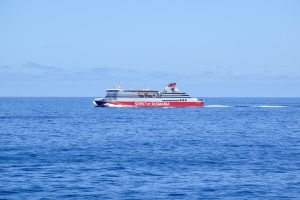
There are two ways to get to Tasmania: by plane, with two main airports located in Hobart in the south and Launceston in the north, or by ferry between Melbourne and Devonport on the north coast of the island. I personnally took the ferry: the crossing takes more or less 9 hours and can be done by day or by night, but you’ll have to pay for a cabin in this case. If you’re lucky you might be able to see dolphins jumping on the waves around the ship!

There is a very severe quarantine in Tasmania. All the vehicles will be checked before boarding on the ferry! It is strictly forbidden to carry fresh fruits, vegetables, honey, fish… (find the complete list of what’s accepted of forbidden here). This is to prevent the spreading of diseases on the island, which is very fragile ecologically speaking. The population of its most iconic inhabitant the Tasmanian Devil for example has been reduced by 70% in the last 30 years because of a contagious facial tumour, and the Tasmanian Tiger (the Thylacine) is extinct since 1936.

It will take you at least 2 weeks if you want to travel all around the island, but a whole month wouldn’t be a waste of time as there are so many beautiful places to enjoy! It’s a paradise for hikers: there are a lot of treks everywhere, and Parks and Wildlife Service of Tasmania made a list of 60 Great Short Walks that you can find here (download it as a pdf here – I’ll signal them with their number when I’ll write about one of those further on). A very expensive daily pass is mandatory to visit all the many National Parks but good news, the “Holiday Pass” that costs 89.50$ per vehicle (price in August 2023) and remains valid for two months is a much more interesting option as it gives you free entrance to all of them.

Finally, if you want to know more about van life in Australia, have also a look at my dedicated article with a lot of useful tips!

North-east of Tasmania

I arrived in Devonport with the ferry on the evening of the 19th of January 2018. During the crossing, I met two Estonian girls, Karin and Marian, and one Belgian guy, Sjoerd, and we decided to travel together for a few days. To seal this new friendship, our first trip together on the next day was to visit some of the multiple wineries from the north of Tasmania! Many of them are located east of Devonport, close to the Tamar River, and in most of them you could do a free wine tasting… which we did! My personal favourite was Holm Oak, a vineyard not so easy to find a bit further off the main road, but with delicious wines. Just remember, drink or drive but not both at the same time!

After this nice introduction, we drove towards George Town, at the mouth of the river Tamar, the second oldest settlement of Tasmania and third oldest city in Australia since it was created shortly after Hobart in 1804. The view from the Low Head lighthouse at the end of the road was pretty, and we also had a surprising encounter with an angry penguin on our way!

We kept going to the east on the next day and made our first stop at the St Columba Falls (Great Short Walk 49); with its 90m it’s one of the tallest of Tasmania. The few hours’ drive until the coast then gave us a good overlook about how diverse this island is: we alternatively crossed alpine-looking hills, vast prairies and even some ancient rainforest.

We eventually reached the stunning Bay of Fires on the north-east coast of the island. Its name doesn’t come from the red and orange colours of the lichen on the rocks, but from the fires that Aboriginal people used to light close to the shore and that the European explorers saw from their ships while they were sailing in these waters. It was my first personal highlight of this trip: I particularly enjoyed the gorgeous and peaceful sight of these little coves and deserted beaches.

East of Launceston, Ben Lomond National Park is a plateau around 1300m in height, with a peak at 1572m (Legges Tor, second highest point of Tasmania). You’ll find a lot of hiking options there!

Halfway between George Town and Launceston is Lilydale, where you can find a very nice free campsite. It features a sheltered BBQ area, toilets, even a fireplace and two nice little waterfalls just 10 minutes’ walk. And if you’re lucky you might get a sunset as impressive as the one below!

There are several basic campsites along the Bay of Fires just above Binalong Bay, all free, but also all very popular. We were there during the high season and it was hard hard to find a spot, but we were eventually lucky enough to secure one directly next to the coast, falling asleep with the sound of the waves and waking up to admire the sunrise… Not too bad isn’t it?

The east coast and Freycinet National Park

After the Bay of Fires, we followed the coast to the south on a beautiful scenic road, with lots of stunning lookouts on the way. We stopped for the afternoon in the little town of Bicheno to see some very impressive blow holes: cracks in the rocks in which the waves are rushing to create real geysers! Still in Bicheno, we also walked on the beach until Diamond Island, a tiny island linked to mainland at low tide (be careful, currents are strong and very dangerous at high tide!). There we met a very friendly local who seemed to enjoy our company a lot: he invited us to have a drink at his place in the evening, but it eventually lasted for the whole night until he offered us to camp in his garden! Which didn’t seem to please his wife so much…

We didn’t stay late the next morning, partly because we didn’t want to cause a domestic quarrel, but also because we wanted to arrive as early as possible at Freycinet National Park further south. It’s one of the most touristic places in Tasmania and there aren’t so many parking spots! The main reason why the Park is so popular is the gorgeous Wineglass Bay, so perfectly naturally shaped that it looks almost like a glass of wine from the sky… It’s possible to admire it from a pretty view point accessible via a relatively short track (Great Short Walk 55), but instead we decided to do a longer hike (11km, around 4h, Great Short Walk 56) that led us through some beautiful landscapes, with local wildlife greeting us on the way!

Still in the National Park, we also went to Honeymoon Bay and the lighthouse of Cape Tourville, both with amazing sceneries…

…and this is where our group splitted! Karin, Marian and Sjoerd wanted to spend one more day in the area, while I kept driving south towards the Tasman Peninsula, once again on a very scenic road along the coast between Freycinet and Orford.

One day is enough to get a good glimpse of Freycinet National Park, but you can choose to stay longer to hike the 30km of the Freycinet Peninsula Circuit (more infos here). It’s also possible to climb to the summit of Mt Amos for a different perspective over Wineglass Bay, but with some rock climbing and very steep sections on the path.

Just before Orford, sail to Maria Island via the ferry in Triabunna; only for pedestrians and cyclists as cars aren’t allowed on this island, which is also a National Park. There you’ll be able to visit the World Heritage Listed Darlington Probation Station and spot a very rich wildlife if you’re lucky! Three of the 60 Great Short Walks (numbers 58, 59 and 60) can be found on Maria Island.

If you’re looking for a place to stay, you can do the same as us and try to meet a friendly local from Bicheno who might invite you to camp in his garden! But there are also many free campsites close to Freycinet National Park, a good option if you want to be there as early as possible.

Tasman Peninsula

This was probably my favourite part of Tasmania, with amazing landscapes everywhere! I had a first glimpse of it even before arriving at the peninsula, with the stunning view over Pirates Bay from the Tasman lookout (to get there, turn left just before the narrow isthmus of Eaglehawk Neck which links the peninsula to the rest of Tasmania).

Down from this lookout, I was surprised by the beauty of the Tesselated Pavements. Here a very rare type of erosion created geometrical shapes, forming a perfectly regular pattern. It looks like it has been built by man, but it’s actually 100% natural! Keep in mind that it’s only visible at low tide.

I turned left after Eaglehawk Neck to admire two other natural sites: the very impressive Tasman Arch (I wondered how it could not collapse!), and the tall cliffs of Devil’s Kitchen at the bottom of which waves were crashing in a foreboding noise…

I kept driving towards the south of the Peninsula, bypassing Port Arthur Historic Site for now but planning to come back later. I first stopped at Remarkable Cave, not that remarkable but in which it is possible to enter at low tide, then I took a gravel road for about ten kilometers until the starting point of the hike I loved the most during my entire trip in Tasmania: the trail leading to Cape Raoul, the southernmost point of the Tasman Peninsula (14km return, 4 to 5 hours, Great Short Walk 6). With breathtaking views, impressive cliffs and even a sea lion colony, it was definitely worth the effort!

The next day, I drove back to visit Port Arthur Historic Site, an unmissable site of Tasmania (also part of Unesco’s World Heritage List). From the 1830’s to the 1860’s, hundreds of convicts were sent to this penal station where living conditions were extremely tough. Only a few returned home… The entrance is quite expensive (42$, price in August 2023) but the visit is very interesting and it allows you to walk freely between the dozens of very well preserved ruins. I really enjoyed learning more about the history of the first european settlers in Tasmania!

Later in the afternoon I visited a second historic site in the north-west of the Peninsula, with free access this time: former coal mines. Here as well, the remains of the buildings allowed me to imagine how precarious the working conditions of the inmates must have been… Follow the Great Short Walk 2 to explore the whole site.

Finally, I left the Peninsula in the early evening to head towards Hobart, about an hour and a half away… but I’ll tell you more about it in the second part of this article!

If you enjoy hiking in luxurious conditions, the Three Capes Track is made for you! It will cost you not less than 595$ (price in August 2023) to follow this trail inaugurated in 2015, and don’t forget to book it weeks or months in advance as access is limited. For that price, you’ll get an entrance to Port Arthur Historic Site where a boat will pick you up for a little cruise and drop you at the beginning of the 48km track. It’s supposed to be done in 4 days with 3 high comfort huts on the way and a bus service also included in the price to bring you back to Port Arthur at the end.

During my road trip in January 2018, I spent a night on a little but very nice campsite directly next to Cape Raoul trailhead, the Raoul Bay Retreat. Only 10$ per night, sauna included to recover from the hike! But unfortunately, I find out now that it has definitely closed in 2020, so unfortunately I don’t have any camping tips to share for this part of Tasmania.

No responses yet

Leave a Reply