Road trip in Tasmania - part II

A little smaller than Ireland, the island of Tasmania has an incredible and unique diversity of landscapes. I spent two weeks there with my van in January 2018, and it sometimes reminded me of Canada, Brittany, Switzerland or even the South of France, while still being 100% Australian. Between nature, history, culture and gastronomy, here is the story of this unforgettable road trip! And if you’re planning to visit Tasmania yourself, this article and the previous one will help you planning your itinerary: I’ll give you a lot of tips about the unmissable sites all around the island, and a list of the best spots to spend the night in a van for free!

Hobart

Despite its quite remote location so far South in the world, Hobart is a very dynamic city where 200.000 Hobartians live. It has gained a lot of international fame especially since the opening of the very peculiar MONA, the Museum of New and Old Arts, in 2011.

The museum is located north of Hobart next to the River Derwent in a huge half underground building. I drove there with my van, but it’s also possible to catch a ferry from the city centre of Hobart. The visit begins by climbing down some winding stairs until the deeper level of the museum, walking into a completely different world. It’s not a usual exhibition. Inside this architectural masterpiece, most of the things you’ll see intend to make you think, shock you or play with your perceptions and feelings. It’s the kind of place you either love or hate. I have to admit that I was personnally quite sceptical in front of some of the works…

Back to Hobart, I left my van on a little parking lot next to Short Beach, then climbed to Battery Hill, the historical heart of the city. I really appreciated wandering in this quiet suburb, enjoying the sight of the many ancient houses around the pretty streets. I kept walking down to the harbour and around the basins, before eventually coming back to my van.

The next morning was saturday, which meant market day! I spent a long time meandering around the stalls of the huge Salamanca Market which happens every week on Salamanca Place.

In the early afternoon, I went back to my van and drove to Mt Wellington (it’s also possible to hike to the summit), overlooking the city from its 1271m and offering a stunning view over the surroundings! Be careful though, as the wind can be very strong: my left door was almost pulled off by a violent gust of wind!

If visiting the MONA wasn’t enough to satisfy your curiosity (or if you didn’t like it!), you can try the Art Gallery and Museum of Tasmania in the center of Hobart. I didn’t visit it myself but I heard that it’s very interesting!

There are also heaps of festivals and events happening in Hobart during the whole year. The most famous are the MONA FOMA (for “Museum of Old and New Art: Festival Of Music and Art”, shortened to MOFO) held in January and its winter version held in June Dark MOFO. Bust as MONA is anything but a “traditional” museum, these events are also very strange and not recommended for everyone…

When I was in Hobart in January 2018, vans seemed to be quite well tolerated in some parts of the city. I spent two nights on the little parking lot with public toilets available next to Short Beach without any problems, not even when a municipal officer came around: he just politely greeted me and left. Remember to be quiet, clean and respectful and everything should be fine!

South of Tasmania

I left Hobart on the Saturday afternoon, following the coastal road between Kingston and Cygnet, much prettier than the direct highway towards Huonville. It was again a great pleasure to drive on this scenic road, with lookouts, beaches and photo stops on the way… Shortly before Cygnet, I took a little detour to a place with one of the weirdest names of Australia: Eggs and Bacon Bay! But despite this funny name, it’s not the most beautiful beach on this part of the coast.

My goal was a little further: Cockle Creek, the southernmost point where you can drive in Australia! It took me quite a while to get there as the last part of the road was unsealed and I didn’t want to drive too fast with my van on this bumpy track, mostly in a good condition but with some rough sections. But it was worth the effort… After about 20 kilometers I eventually reached the End of the Road, as proclaimed by a wooden sign!

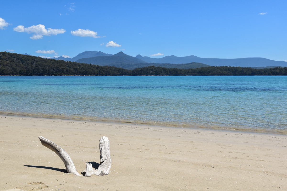
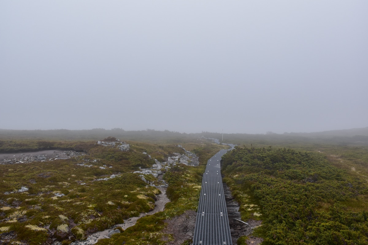
If you want to go further, you’ll have to walk! The next morning, I followed the beautiful trail towards South Cape Bay from Cockle Creek campground, crossing successively some patches of tropical forest and vast empty plains (Great Short Walk 9, 15km return, around 4h). The view over the bay at the end of the track was breathtaking, with South-West Cape to the left, the southernmost point of Tasmania… From here, I was closer to Antarctica than to Cairns in the north of Queensland!

Knowing that I was so far south in the world, already in the Roaring Forties where the climate is known to be rough, I expected to find quite a hostile region. But instead I was surprised to discover a series of heavenly beaches, with a wonderful view over the mountains in the background. The water was even surprisingly warm, and it was a pleasure to go for a swim!

At Kettering, on the coastal road between Kingston and Cygnet south of Hobart, you can take a ferry to cross the D’Entrecasteaux Channel and reach Bruny Island in about twenty minutes. This island in divided in two distinct parts, north and south separated by a narrow sandy isthmus, The Neck, and is home to the South Bruny National Park. Follow this link for more details.

The South Coast Track might be the most arduous trek of Tasmania. It starts in Melaleuca, a remote locality that is accessible only by plane or by boat as no roads lead there. There is neither accommodation nor any water supply along the 85km track until Cockle Creek so it’s reserved for very experienced bushwalkers only.

There are two large free campsites at Cockle Creek. Very rudimentary (no water, only one toilet) but what an awesome location… You couldn’t be closer to the beach, and at night time the sky is incredible. Both were almost full when I arrived on the Saturday, but most of the people left on Sunday as it was the end of the Australian holidays!

My campervan underneath the Milky Way in the far south of Tasmania

Cradle Mountain

During my entire trip in Tasmania, the only day of really bad weather was when I left Cockle Creek and the south of the island to head towards the north, through Hobart, Derwent Bridge and Queenstown. I wasn’t able to enjoy the supposedly beautiful landscapes along the way, but at least I was lucky enough that it happened on the day I had planned to drive the most…

This is actually quite typical to the region of Cradle Mountain: the weather can change extremely quickly, several times during the day. When I arrived at the National Park in the morning there was a clear blue sky; it started raining around noon, it was foggy at 1pm, sunny again at 2, rainy at 3 and snow was expected in the late afternoon! I took the following pictures on the same day, within a few hours only…

But it doesn’t prevent Cradle Mountain National Park to be one of the main touristic attractions of Tasmania, especially because of the Overland Track (see below). Hundreds of tourists come here every day. I had to leave my van on a parking lot next to the Visitor Centre at the entrance of the Park, then take a free shuttle until the starting point of the differents trails.

I started with a little stroll on the shore of Dove Lake, a pretty lake with the impressive silhouette of Cradle Mountain in the background (Great Short Walk 29), then climbed to Marion’s Lookout via Crater Lake (Great Short Walk 31), on a path with some steep sections but with a gorgeous panorama as a reward! In my opinion, if there was only one walk to do in the Cradle Mountain National Park, it would be this one.

After that, I kept hiking to the summit of Cradle Mountain (Great Short Walk 32). If the walks mentioned before are suitable for anybody, this one is way more difficult. The last part to the top is basically rock climbing, sometimes on almost vertical sections! Not recommended for people who are afraid of heights (going down was very difficult for me…), and the track is closed when it’s raining or snowing. But at least the 360° view from the summit is once again really gorgeous!

This is certainly the most famous trek of Tasmania, and it’s considered to be one of the most beautiful hikes of Australia: the Overland Track! It starts at Ronny Creek and ends after 65kms next to Lake St Clair, Australia’s deepest lake, with many side trip options along the way. You have to book in advance between the 1st of October and the 31st of May and pay a fee of 285$ (price in August 2023 – it’s free though and no booking required between June and September). Be careful, during peak season (January-February) the track might be fully booked weeks in advance. Find all the information you need here.

If that still wasn’t enough hiking for you, you can also explore the Walls of Jerusalem, one of the most secluded National Parks of Tasmania. There are no roads inside of the Park so you’ll have to follow a gravel track until a car park at the entrance and then start walking from there. More details here.

Based on the amount of people going to Cradle Mountain every day, I recommend to spend the night as close as possible to the Park to be there early in the morning and avoid the crowds. I personnally slept on a nice freecamp in Tullah, next to Lake Rosebery, about one hour’s drive away, but there might be possible to stay even closer.

The north-west coast

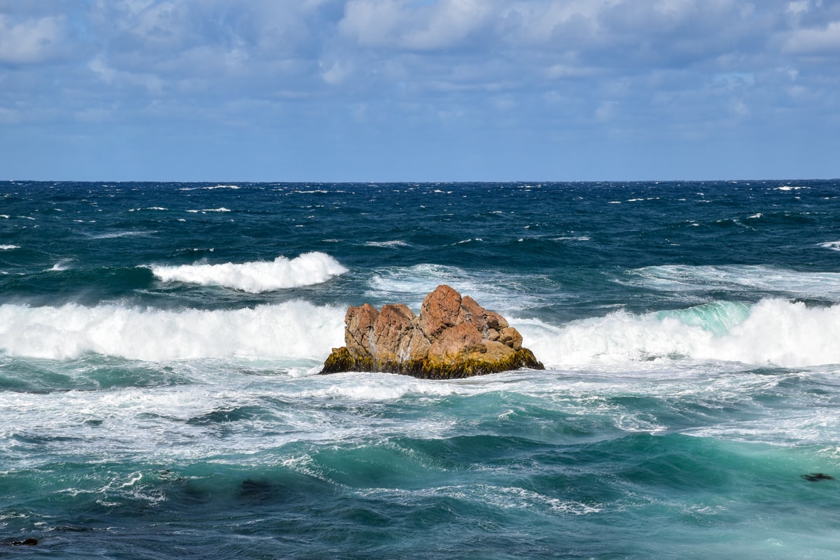
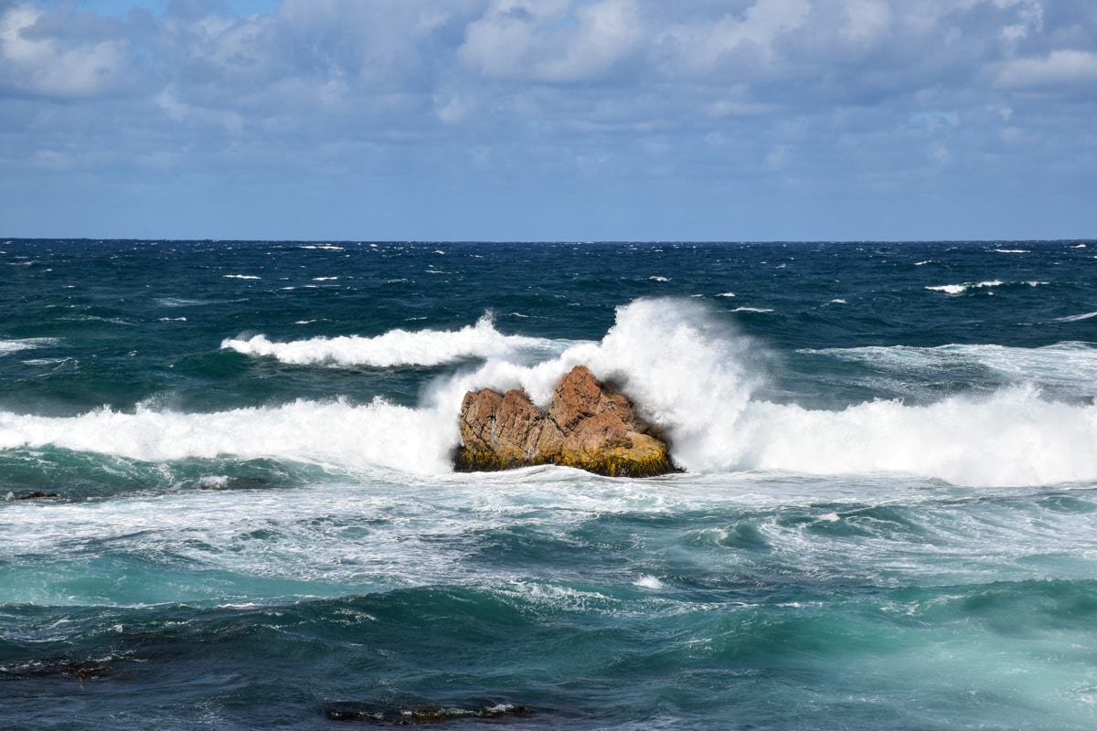
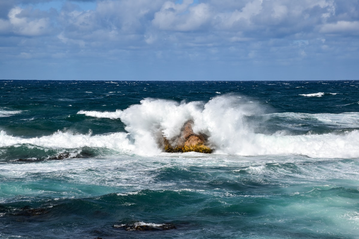
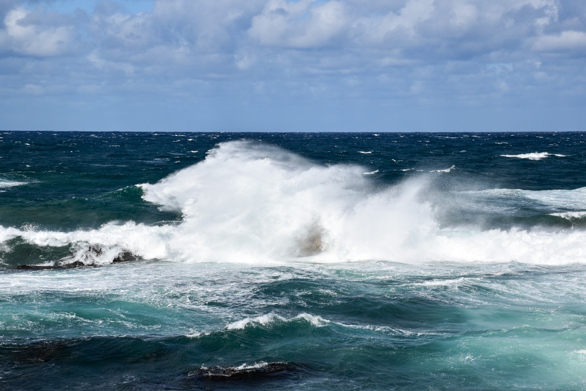
After the Bay of Fires, Freycinet National Park, the Tasman Peninsula and Cradle Mountain, I thought that there wasn’t so much more to see in Tasmania. Big mistake! The last days of my road trip in the north-west of the island were again filled with a lot of amazing moments. I first drove to Arthur River, the westernmost point of my trip. The rugged and very windy coast around this little village is worth the view. One of the lookouts is even called The Edge of the World! Not entirely wrong as it really looked like the world was ending there…

The sight was equally amazing a little further at Bluff Point, were strong waves were smashing rocks in an explosion of foam…

I then slowly began to head back to the east, towards Devenport and the ferry to mainland. First stop: Stanley and its famous “Nut”, a big rock of volcanic origin, 150m above the ocean! A little chairlift leads to the summit, but I chose to climb the very steep path instead. The Great Short Walk 34 circles the entire summit, offering beautiful views over the surroundings.

Second stop about 30km further at Rocky Cape, the smallest National Park of Tasmania. I didn’t stay long, just enough for a stroll to two ancient caves where Aboriginal people used to live and to enjoy the view over the coast from the lighthouse.

Thirty kilometers more and I arrived at Table Cape, close to the city of Wynyard, another promontory with the same volcanic origin than the Nut in Stanley, and where I again did a beautiful walk along the coast. This place is particularly good to visit in October when the huge tulip fields around the lightouse are blooming. Fun fact: Wynyard even exports tulip bulbs to the Netherlands!

I then drove away from the ocean for the last time, towards the quite impressive Leven Canyon. The panorama can be enjoyed from two spectacular lookouts, linked by a footpath (Great Short Walk 36). Be aware that there are no less than 697 steps on the way; a good tip is to do the loop anti-clockwise and begin with Cruickshanks Lookout to climb the steps down and not up…

Finally, what would a trip to Tasmania be without seeing its most famous resident, the Tasmanian devil? Unfortunately these Aussie icons suffer from an aggressive facial tumor and their population is quickly decreasing so it’s really hard to spot them in the wild. The best way to see them is visiting one of the many wildlife reserves around the island. I personnally went to the Wings Wildlife Park close to Leven Canyon; I found it a bit expensive (27$ back in 2018, 31$ in August 2023) so there might be cheaper options, but at least I was finally able to see some devils!

It’s with this last visit that my road trip around Tasmania ended! I took the ferry back to Melbourne on the next day, with plenty of memories in my head… and hundreds of pictures in my camera! If you ever go to Tasmania, I hope that you’ll enjoy your trip as much as I enjoyed mine, and that this article and the previous one would have been useful!

Between Smithton and Arthur River, the Tarkine Drive will be a nice way to explore more of the countryside of North-West Tasmania, with forest, rivers, lookouts and short walks along this scenic drive.

Still close to Arthur River, you’ll be spoilt for choice with great free campsites! I personnally stayed at Marrawah Green Point, on a windy night next to the beach.

Probably my favourite camp site of Tasmania: Boat Harbour, between Stanley and Wynyard, a large free campground in front of an extraordinary beach. I even was lucky enough to be there during a “super moon” and spent half of the night just staring at the sky!

Finally, I spent my last night on one of the many free campsites around the city of Penguin, only 40km away from Devenport (ideal to catch a morning ferry). I opted for the one at Sulphur Creek, with public toilets about 200m away. Icing on the cake, on the same evening I enjoyed a beautiful sunset and saw a few penguins!

No responses yet

Leave a Reply